

Restoration Condition Trajectory compares satellite-observable surface conditions across an explicit multi-year baseline and monitoring period. GeoRetina AI combines annual vegetation and moisture indices with land-cover context to show what changed, where the change occurred, whether the evidence is sufficient, and when field review is recommended.
Observed change, not causal attribution
This analysis describes satellite-observable condition change. It does not establish that restoration caused the change, verify ecological recovery, or classify a project as a success or failure.
When to Use It
- Compare a restoration or stewardship area before and after an intervention or management period.
- Monitor revegetation, wetland, riparian, pasture, or reforestation condition using matched seasons.
- Separate a multi-year directional signal from year-to-year variability.
- Identify locations and evidence gaps that should be prioritized for field review.
How to Ask
Provide one polygonal region of interest, at least two baseline years, at least two monitoring years, and one seasonal window that applies to every year.

Restoration condition
Assess the restoration condition trajectory in @project_area for May through August, comparing 2018–2019 with 2024–2025.
Wetland monitoring
Compare the summer surface-condition trajectory of @restored_wetland using 2019–2020 as the baseline and 2024–2025 as the monitoring period.
Riparian stewardship
Assess observable vegetation and moisture change in @riparian_corridor between the 2018–2019 and 2024–2025 growing seasons.
Field review
Run a restoration condition trajectory for @stewardship_area and explain why field review is or is not recommended.
Outputs
The workflow can return:
- An evidence state:
change_supported,change_not_supported, orinconclusive. - Annual median NDVI and NDMI measurements for valid analysis years.
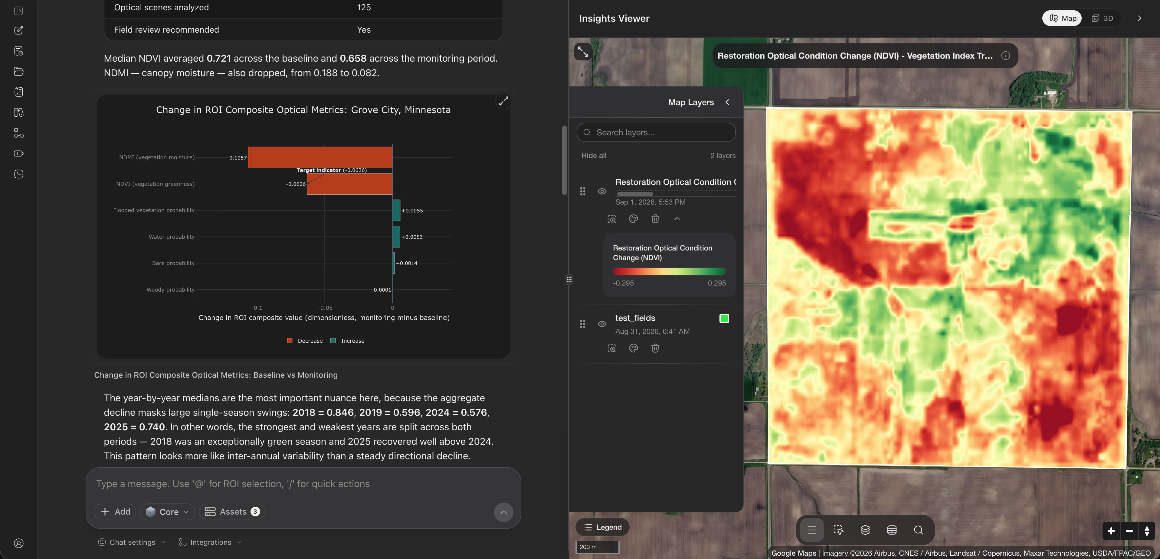
- Baseline-to-monitoring changes in vegetation, moisture, water, flooded vegetation, woody cover, and bare-cover probabilities.
- A monitoring-minus-baseline NDVI change raster and reusable map layer.
- Valid-year, usable-observation, spatial-coverage, and field-review information.
- Optional Sentinel-1 measurements as complementary context when they pass quality checks. Radar context does not alter the primary optical evidence state.
Reading the Annual Trajectory
Start with the annual values rather than the period averages alone. They show whether an aggregate change reflects a consistent direction or large swings between individual seasons. Years without sufficient imagery remain gaps rather than being interpolated or replaced.

In this example, the aggregate decline masks substantial inter-annual variability. NDVI falls from 2018 to 2024, then rebounds in 2025. The pattern is not a steady directional decline, which is why the annual trajectory and field context matter.
Reading the Land-Cover Context
Land-cover composition helps explain whether the index pattern coincides with a broader surface-cover shift. Treat small class changes as context for review, especially where the region is dominated by one class or contains mixed pixels.

Here, cropland remains dominant while tree cover increases modestly. That woody-cover signal may justify closer inspection, but it does not by itself demonstrate restoration success or ecological function.
Understanding the Evidence State
| State | Meaning |
|---|---|
change_supported | The available observations meet the selected satellite-observable change definition. |
change_not_supported | The evidence is sufficient, but the selected change rule is not met. This is not evidence of restoration failure. |
inconclusive | The available observations, valid years, spatial coverage, or another evidence requirement are insufficient. |
Best Practices
- Use the same ecologically meaningful seasonal window in every year.
- Include at least two years in both the baseline and monitoring periods.
- Draw the ROI around the intended project or stewardship area rather than a much larger mixed landscape.
- Review annual values, the delta map, land-cover context, evidence reasons, and field records together.
- Treat intervention dates as context only; the analysis does not estimate causation or additionality.
- Use field observations or local records before making management, funding, compliance, or certification decisions.
Useful Follow-ups
- "Which annual values have the greatest influence on the evidence state?"
- "Explain each reason for the field-review recommendation."
- "Where are the strongest increases and decreases on the NDVI change map?"
- "Create a concise monitoring report with the evidence state, annual trajectory, map, and limitations."